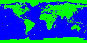
Map of the World
180 x 90 (1 - 30 players)

Recommended ruleset: Earthly Nations
Screenshots

|

|

|
| Europe | Australia | Indonesia |

|

|
| Caribbean | Near East |
180 x 90 (1 - 30 players)

Recommended ruleset: Earthly Nations

|

|

|
| Europe | Australia | Indonesia |

|

|
| Caribbean | Near East |
The map tries to be as accurate as possible (in the projection of the globe described on the main page) as regards the shape of the continents, allowing the inaccuracy of approx. 2 degrees in the lattitude or longitude wherever an important detail was to be shown (for instance, main islands are charted even though many of them are smaller or narrower than two degrees). Chief archipelagoes consisting of small islands are marked with one square in the center of the area (except for Hawaii and Galapagos, which are allowed two squares); this correctly makes the Pacific and other oceans both "empty" and still capable of building military airbases (such as Guam). Land squares touching by corners are used to render narrow straits that can easily be crossed by units both ground and marine.
Unlike most maps of the world for Civilization games that fit the terrain types to game purposes (avoiding large uninhabitable areas), this map is based on geographical considerations in the first place, which makes it more realistic. If considered at all, the playability was achieved rather by letting it generate special resources than altering the terrain. (The map would be more realistic if the special resources were placed where they belong in the real world; this may be done in some future version.)
The first criterion for the selection of the terrain type has been the relief. Mountain ranges higher than approx. 4000 m above the sea level are rendered as the terrain type Mountains, lesser mountainous regions are rendered as the Hills; some smaller mountains which are covered with forests are often rendered simply as Forests or Jungle.
The basis for the choice of terrain types for flat regions has been the prevailing agricultural utilization of the area (or prevailing vegetation in unexploited regions), assuming that the actual utilization shows what the region is best fit for. Since the game starts before civilization uprose on the Earth, it would perhaps be more accurate to show the original vegetation type before any cultivation; the map may perhaps be further corrected.
Of the rivers only the principal ones are put on the map (in their lower course), though no exact criterion (like outflow) has been adopted. Some rivers (e.g. Elbe) could not be included, because the coast line would make a delta that the river actually does not form, even though some rivers smaller than these are included (e.g. Po - I just couldn't help including it, it fit there so nicely).
My experience shows that the map simulates the real world reasonably well - the civilizations follow the main directions in which the real historical civilizations spread and roughly similar utilization of various regions (except that specials make some regions too rich, e.g. Siberia).
The birthplaces of the civilizations have been selected as they are partly because of historical reasons (in the spots where great civilizations were founded), partly of playability reasons (not to make some regions overcrowded and others empty). I have intentionally included three locations that are almost certainly a loss, namely those on the islands that are not sufficiently big to sustain a new-born civilization (Madagascar, Japan, and especially New Zealand which cannot be escaped with triremes): these can be used for a handicap game.
I recommend to use the Earthly Nations ruleset (which is a slightly edited version of the default nations.ruleset) for this map in order to get a more realistic experience. In the first place, you don't meet Dúnedain and Mordors in this historical environment; and the list is further shortened and reordered to fit to the birthplaces of the present map. The continents look more familiar if non-isometric tiles (e.g., Trident) are used.
| Version | Date | Features |
|---|---|---|
| current | 2001-Dec-27 | Riversoverlay, specials reduced to 125, earthly nations, several squares altered. |
| v.1-2 | 2001-Aug-05 | Fogofwar and spacerace set 1. |
| v.1-1 | 2001-Jul-28 | The first release. |