Map of the Ice Age World
180 x 90 (1 - 30 players)
Recommended ruleset: Earthly Nations
Screenshots
| Ice Age | Modern |
|---|---|
 |
 |
 |
 |
 |
 |
180 x 90 (1 - 30 players)
Recommended ruleset: Earthly Nations
| Ice Age | Modern |
|---|---|
|
|
|
|
|
|
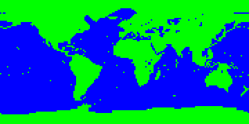
The map shows the world as it might have looked during the Last Glacier Maximum (LGM), ca 20,000 years ago. It is based on several reconstructions of the landscape and vegetation of that era; these were put (somewhat arbitrarily) together and rendered with game terrain tiles, trying to achieve at least some level of similarity to the supposed LGM conditions. The map thus makes no claim of scientific accuracy and must be viewed just as an interesting game environment, resembling in some respects the conditions of the LGM, and reflecting to a certain degree their recent reconstructions (the author of the map is a FreeCiv player, not a Quaternarist). The main source for the reconstruction and "translation" into FreeCiv terrains was the Global Atlas of Palaeovegetation since the LGM by Jonathan Adams of the QEN project, which can serve as a more detailed source of information about the LGM conditions.
The disclaimers made, here is some basic information about the map and its preimage. The period of LGM was chosen (of all Ice Age stages) for the simple reason that it is the closest (and therefore the best reconstructed) of those glacial phases that are most different from the present state of affairs (since we are climatically still close to the climatic optimum which occurred 8,000 years ago). The map was derived from the Big Map of the Modern World (version 1.3).
The general picture of the LGM world is the following: since large parts of the northern hemisphere were covered by ice sheets (containing vast amounts of water), the sea level was about 130 m lower than today, thus exposing parts of the continental shelf and forming several land bridges. The climate was generally colder and drier, vegetation zones were moved equatorial-wards, rainforests were reduced and the areas of desert or semi-desert expanded (there were, however, some local exceptions to this rule).
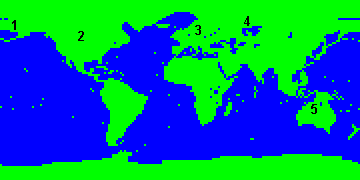
The many differences between the LGM and modern maps can best be observed by playing or investigating the map itself. Those worth mentioning are perhaps the great lake in Western Siberia formed by the damming of the rivers Yenisei and Ob by ice sheets (I accept its existence for the sake of more interesting games; this may be the case with other possibly uncertain features, too, though I am willing to adjust the map to any firm knowledge I may hear of); smaller proglacial lakes are scattered along the main ice sheets. You may also notice the land bridges connecting New Guinea and Tasmania to Australia; Japan, Lanka and Indonesian islands to Asia; the land bridge of Beringia, connecting Alaska to Siberia; the greater extent of the Caspian Sea; and many areas of the exposed shelf.
Since the landmass is rather expanded relative to the map of the modern world from which it is derived, I did not alter the starting positions of the nations (although some of them are now too northern). I recommend using the Earthly Nations ruleset, though making entirely new nations (and techs) for ice age cultures would of course be more preferable: anybody is welcome to make them. The continents look more familiar if non-isometric tiles (e.g., Trident) are used.
The start year and the end year are left -4000 and 2000, since all of us are used to these. However, they cannot be taken for the "real" time scale, since should the history covered by the game be 6000 years, the landscape would have to change significantly (about 12,000 BC, the ice sheets already began melting). This is not yet enabled by FreeCiv scenarios (even though smaller landscape changes occurred even between 4000 BC and 2000 AD), so the dates must only be taken as indicating the progress of the game, not real time.
Playing this scenario, we can experience what the world would be, had the civilization uprisen some 15,000 years earlier than it actually did, and get some feeling of the climatic conditions humankind experienced not so long ago (and may well experience several millenia later, for during the cold Quaternary, ice ages prevail ten times in length over interglacials). When playing it for the first time, my impression (of someone familiar with the corresponding map of the modern world) was twofold (and quite strong, even though the facts were expected): the depressive look of the cold and barren lands where I was used to see fertile fields; and the "Where has all the water gone?" misdoubt. (Even though there is no indication of the sea depth in FreeCiv, it really looked as if some water had flown out of the tub.) However, once I got used to the LGM map, the common modern map started to seem to me too warm, too wet, excessively fertile, and sinking. (Not to think about even warmer eras in the Earth's history, like Eocene or Jurrassic!) At any rate, when playing this map one can find that some of our fixed geographical conceptions are of a very ephemeral nature.
Since the LGM world was in many respects similar to the modern one, many topographical names apply directly to it. The following schema lists only those that cannot be found on modern maps.
Legend:
Other parts of the exposed shelf can be called by the name of the shelf or the adjacent land.
| Version | Date | Features |
|---|---|---|
| current | 2004-Dec-30 | Freeciv version, save_name. |
| v.1-1 | 2002-Dec-29 | The first release. |